
The Great Rift Valley is a continuous series of geographical furrows that run across a few places in the world. The Rift Valley can only be sighted in a specific place in the world and mostly in Africa. The Rift Valley in Africa separates the regions into two major areas- the western rift valley and the eastern rift valley.
There are two major rifts in Africa: the East African Rift and the Gregory Rift. These are the best places to see the Rift Valley in all its might;
1. Mai Mahiu Longonot View Point – Kenya

Mai Mahiu Longonot View Point is a panoramic and scenic point found in Kenya along the Mai Mahiu – Naivasha road at Kimende. The viewpoint provides a breathtaking and wide view of the rift valley and Mt. Longonot, one of the mountains that were formed as a result of the Great Rift Valley.
At the viewpoint, there are curio shops where one can buy African antiques and handmade souvenirs such as ornaments, belts, Maasai sandals, and Maasai clothes. From the Longonot viewpoint, you can see an Earth station which is on the floor of mount Longonot. The station can only be seen from the peak of mount Longonot and the viewpoint and has restricted access. The viewpoint is a free-stopping area where people get a perfect and clear view of the rift valley and can take photos for free.
2. Mau Escarpment – Kenya

The Mau Escarpment is a steep slope along the western side of the Great Rift Valley found on the western side of Kenya near Nakuru. It is steep and its western slope has a large forest called the Mau Forest.
The top of the escarpment is 1000m high from the floor of the Great Rift Valley. The Mau forest is a very large area of 675,000 acres in size. The forest is the largest montane forest in East Africa. The forest has caused a high rainfall rate, hence, many rivers originate from this forest and feed into other lakes in Kenya. Mara River, Ewaso Nyiro, Sondu River, and Njoro River from this forest feed lakes like Lake Victoria, Lake Natron, and Lake Nakuru.
3. Olduvai Gorge – Tanzania
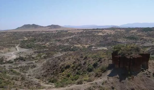
The Olduvai Gorge in Tanzania is one of the most important archaeological sites in the world found in Tanzania. It is found on the eastern side of the Serengeti in the Ngorongoro Conservation Area. The name Olduvai comes from the Maasai word olduvai which means “the place of the wild sisal” since the area of the gorge is covered with the East African wild sisal.
It is a steep ravine of about 45 km in length and 89m in depth that was formed from the wearing and erosion by rivers. It is mostly known as the oldest evidence of the first humans. A big number of fossil bones and old aged stone tools that are a million years old have been found in this place.
The gorge is a part of the Great Rift Valley found between the Ngorongoro crater and the Serengeti which were formed as a result of the formation of the rift valley. There are two lakes near the gorge- Lake Ndutu and Lake Masek which are also a result of the formation of the faults of the rift valley. The gorge cuts into several rock beds with the oldest dating up to 2 million years old. There is a monolith found in the area, made of red sediments.
There is a side gorge found near the main area of the Olduvai Gorge with a prehistoric lake that has held water for over a million years. There is a museum, Olduvai Gorge Museum, where visitors get to learn more about the cradle of mankind and see some of the artifacts collected and exhibited to show the evolution of humans.
4. Afar Window In The Eastern Ethiopian Escarpment – Ethiopia

The Afar Window is found in the South of Debre Sina, Ethiopia. The Afar Depression, also known as the Afar triangle, was formed as a result of the Afar Triple junction which is a part of the Great Rift Valley in East Africa.
The ridges caused by the junction form the Red Sea and the Gulf of Aden. The ridges at the Afar triangle have spread further due to the volcanic eruptions of the Dabbahu and Erta Ale volcanoes. The Afar triple junction joins with the Kenyan rift valley. The escarpment is formed by river erosion and given its shape by the massive landslides. The escarpment is over 1000m high.
5. From The Slopes Of The Mountain Ol Doinyo Lengai – Tanzania
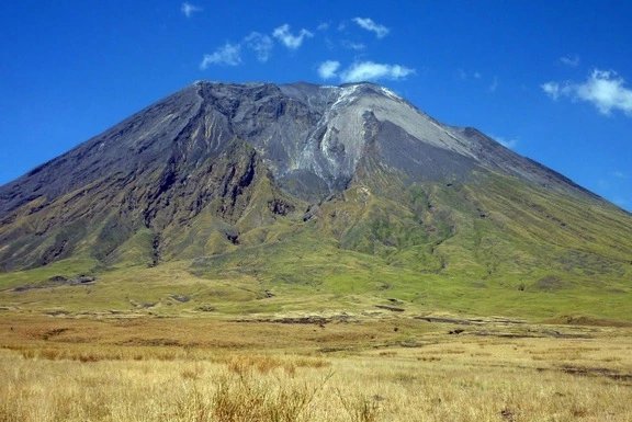
The name Oldoinyo Lengai is a Maasai name meaning “the mountain of God”. It is found on the southern side of Tanzania near Lake Natron. It is located in the Gregory rift and it is an active volcano.
Ol Doinyo Lengai is 2,800 meters high and it is a part of the East African Rift System. It is known as the only active volcanic mountain that erupts natro carbonatite lava-a type of lava that contains no silicon at all. The mountain is quite steep although it is half the height of Mount Kilimanjaro. The panoramic view from the peak of the mountain is breathtaking.
The outer slopes of Ol Doinyo Lengai have parasitic cones and craters. Since the mountain rises from the East African Rift System, the view of the Rift Valley floor is amazing from the slopes of Ol Doinyo Lengai. From this mountain, you can see the Ngorongoro highland, Lake Natron, the Ngorongoro escarpment, Mount Kitumbini, and Mount Gelai.
- Elgeyo Escarpment – Kenya

It is a fault slope caused by faulting. The escarpment is on the western side of the Great Rift Valley. It is found in Elgeyo Marakwet, Kenya. The escarpment is 2,450 meters high and near it is the Tarok Waterfall. There are three zones that are parallel in this zone of the rift valley: a highland plateau of Cheranganyi hills, the Elgeyo escarpment, and the Kerio valley.
The height of the escarpment gives the valley a great scenic view from the top of the escarpment wall. The Elgeyo escarpment has offered sports like paragliding that need great height and the perfect wind speed for the sport. Views of the Tarok waterfall, Kerio valley, Tugen hills, and the mountain tops of Mt Longonot and Mt Kenya.